Where is Kenya?
www.embassy-of-kenya.de
Kenya lies astride the equator on the eastern coast of Africa. It is a medium-sized country by continental standards; covering an area of about 586,600km sq.
Inland water bodies cover some 10,700km sq, the bulk of this in Lakes Victoria and Turkana.
Kenya is bordered by Somalia and the Indian Ocean to the east, Ethiopia to the north, Sudan to the northwest, Uganda to the west and Tanzania to the south. The coastline, about 550km long, faces the Indian Ocean.
Kenya has tremendous topographical diversity, including glaciated mountains with snow-capped peaks, the Rift Valley with its scarps and volcanoes, ancient granitic hills, flat desert landscapes and coral reefs and islets.
However, the basic configuration is simple. Coastal plains give way to and inland plateau that rises gradually to the central highlands, which are the result of the relatively recent volcanic activity associated with the formation of the rift valley.
To the west the land drops again to the Nyanza plateau that surrounds the Kenyan sector of Lake Victoria; and to the north, to the rugged low country around Lake Turkana.
The coastline is broken and composed of beaches, coral cliffs and reefs, creeks and numerous offshore coral islands. Inland, a mainly level but narrow coastal plain lies on sedimentary rocks, with some igneous intrusions such as Dzombo and Mrima.
Beyond low rolling hills lies the so-called Nyika Plateau, mainly on sedimentary rocks.
This landscape covers almost the entire northeastern sector of the country, on very gradual slopes.
The Great Rift Valley, with its associated escarpments and mountains, is a major feature. It runs the length of the country from Lake Turkana in the north to Lake Natron on the southern border with Tanzania.
The central portion of the rift is raised, with the Aberdare Mountains and Mt Kenya to the east and the Mau Escarpment and Cherangani Hills to the west.
The northern and southernmost sectors of the rift are low-lying, arid and rugged, with spectacular volcanic landforms.
The region west of the central highlands is characterized by Precambrian metamorphic rocks and linear basement hills. Mt Elgon, an old, eroded volcano, intrudes through the ancient shield on the Uganda border.
The lake Victoria basin generally has a gently sloping landscape and an eroded surface that exposes granitic outcrops.
Isolated hills and mountains, such as Mt Kulal, Mt Nyiro and Mt Marsabit, are scattered to the north and east of the central highlands.
The Taita Hills, rising from the southeastern plateau, are ancient fault-block formation, the northernmost of a chain of isolated peaks (the ‘eastern arc’) that stretches south to Malawi through eastern and southern Tanzania.
They sit almost cheek-by-jowl with one of the region’s recent volcanic ranges, the Chyulu Hills.
Kenya's Climate
Kenya is generally a dry country; over75% of its area is classed as arid of semi-arid with only around 20% being viable for agriculture.
Inland, rainfall and temperatures are closely related to altitude changes, with variations induced by local topography.
Generally the climate is warm and humid at the coast, cool and humid in the central highlands, and hot and dry in the north and east.
Across most of the country, rainfall is strongly seasonal, although its pattern, timing and extent vary greatly from place to place and from year to year.
The relatively wet coastal belt along the Indian Ocean receives 1,000 mm or more rain per year. Most rain falls from April to July as a result of the southeasterly monsoon.
Another moist belt occurs in the Lake Victoria basin and its surrounding scarps and uplands, mainly due to moist westerly winds originating over the Atlantic Ocean and Congo Basin.
Except immediately adjacent to the Lake, rainfall occurs reliably from March to November.
The upland plateau adjacent to this area are less influenced by the lake, and rain falls mainly in March-May and July-September. In much of the central highlands, there is also a bimodal rainfall pattern, with rainy seasons in March-May and October-December.
The remaining 70% or so of the land area falls into the ‘arid lowlands’ zone (NRI 1996), with rainfall averaging less than 500 mm and varying greatly from year to year.
Rainfall peaks in most areas are in November and April. Some 30% of this zone can be classed as semi-desert, with rainfall averaging less than 300 mm per year and evaporation often greater that 3,000 mm.
Except for the coast and Lake Victoria region, altitude is the main determinant of precipitation.
The high-attitude areas (over c. 1,500 m) in the central Kenya highlands usually have substantial rainfall, reaching over 2,000 mm per year in parts of the Mau Escarpment.
However, topography also has a major influence, with strong rain-shadow effects east of Mt. Kenya and the Aberdare mountains.
Here, even areas higher than 1,800 m may be relatively dry. In the arid lowlands the peaks of isolated mountains attract cloud and mist, and may support very different vegetation to that of the surrounding plains.
Differences in temperature vary predictably with altitude.
Frost occurs regularly at 3,000 m and occasionally down to at least 2,400 m, and there is permanent snow and ice on top of Mt. Kenya at 5,200 m.
The hottest areas are in the arid northeast, and west of Lake Turkana, where mena maximum temperatures average over 34 C.
Kenya's Water resources
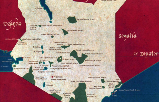
All Kenya’s major river drain from the central highlands, divided by the rift into those flowing westwards into Lake Victoria and those flowing eastwards towards the Indian Ocean.
There are five major drainage basins: Lake Victoria, the Rift Valley, the Athi-Galana-Sabaki River (and Coastal areas to its south), the Tana River and the northern Ewaso Ng’iro.
Kenya only has a small part of Lake Victoria’s water surface, but the Kenya catchment contributes a disproportionate 33% of its surface inflow, some 470 million cubic meters a year.
The rift valley contains several basins of internal drainage, forming a chain of endorheic lakes from Lake Natron on the Tanzanian border, through Lakes Magadi, Naivasha, Turkana, Elementaita, Nakuru, Bogoria and Baringo.
These lakes vary in alkalinity; from fresh water Lake Naivasha to the intensely alkaline Lake Magadi.
Lake Turkana is notable as a major volume of (more or less) fresh water in an otherwise arid and barren part of the county, while a number of rivers, including the Turkwel, Kerio, Athi-Galana, Tana and Northern and Southern Ewaso Ng’iro, flow for long distances through dry parts of the country.
Latest news
On December 12th, Kenya celebrates its national holidayOn December 12th, Kenya celebrates its national holiday, marking two key events in the country's history ...
Tens of thousands of people cheered as His Excellency Hon.William Ruto was sworn in as Kenya's president at a ceremony in the capital NairobiTens of thousands of people cheered as His Excellency Hon. ...
VisasVisitors to Kenya are required by law to have passports with validity of not less than six months and prerequisite visas ...
MAIN CONTACTS
Visas can be obtained at the Kenya Embassy in Berlin.
CONTACT CONSULATE IN SOFIA:
3, Pozitano Street, 2nd floor, 1000 Sofia, Bulgaria
tel./fax: (+3592) 986 58 96; 988 26 52
e-mail: consulate@kenya-bulgaria.org
Facebook: https://www.facebook.com/consulatekenya.bulgaria
Working Hours:
10:30 – 12:30